TARCOG Small Business Success Stories
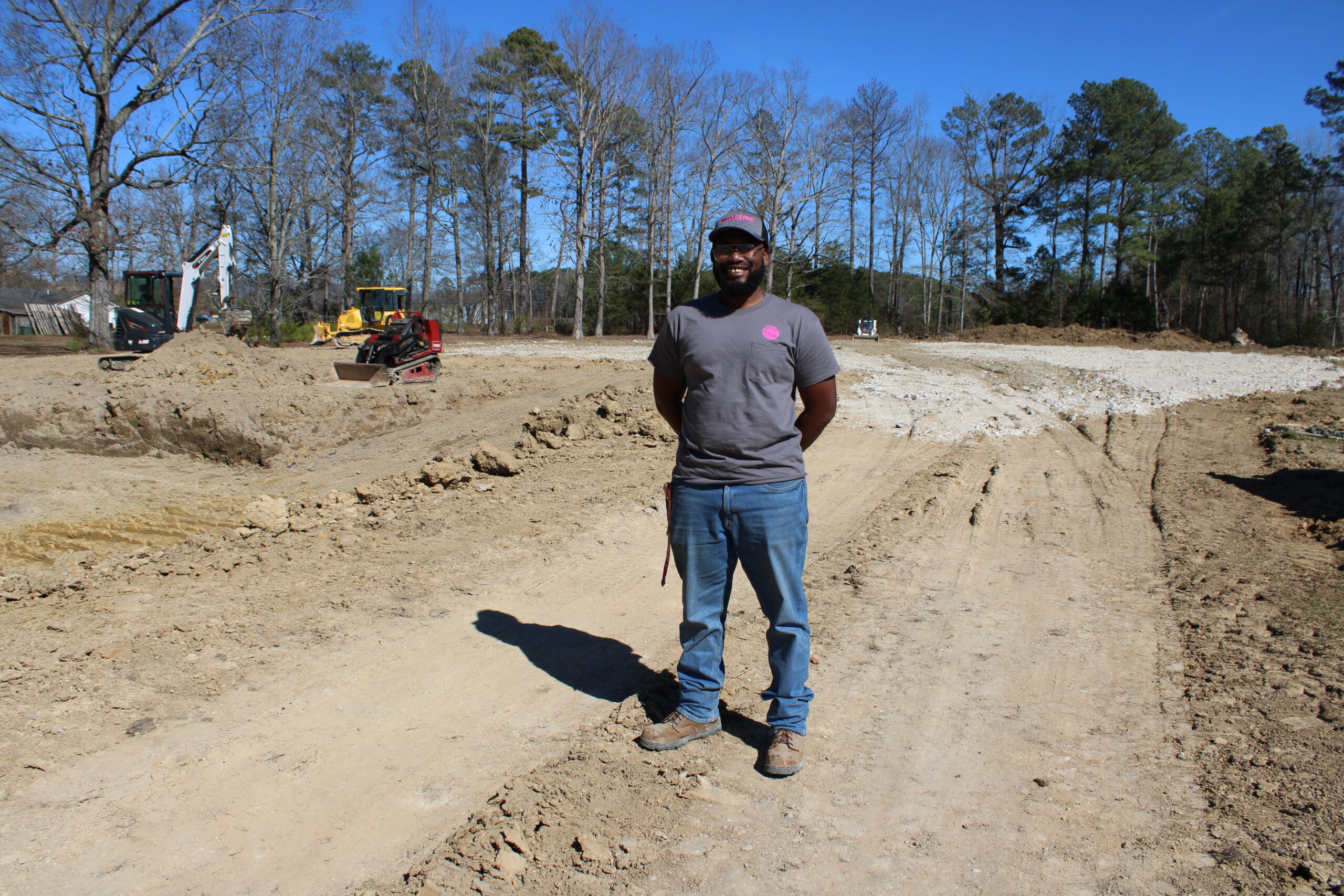
Maurice “Mo” Haywood at his new landscape business, MoScapes, 9465 US Highway 431, Owens Cross Roads
At age 31, Maurice “Mo” Haywood is living his dream of owning a business with the help of TARCOG’s Revolving Loan Fund (RLF).
He’s following in the footsteps of a restaurateur and antiques dealers who own thriving businesses today thanks, in part, to the same fund. That’s why the RLF can be a game changer for entrepreneurs looking to start or grow their businesses in northeast Alabama and they all make an impact on the local economy.
Lee Terry, TARCOG’s director of Economic Development and Planning, said Mo’s loan was recently approved so he could start MoScapes, a landscape materials business. He said TARCOG partners with Neighborhood Concepts, Inc., (NCI) to administer its RLF through the North Alabama Revolving Loan Fund, LLC.
MoScapes, 9465 US Highway 431, Owens Cross Roads
It’s an exciting time for Mo, who is literally building his new business from the ground up. He worked with a crew moving and building up dirt for the foundation of his operation at the end of February with plans to have his storage bins up and ready to start selling bulk materials in March and a new building completed in April.
He worked at another local landscape business for 10 years as its hardscapes operations manager. He knows and understands the business and is ready to make his first sale. But it didn’t happen overnight. When Mo got serious about starting his own business, his mother gave him a contact at NCI. He followed their advice and secured the non-traditional funding route that helped him get started.
“It was a process, but they helped me every step of the way” he said.
The tagline for MoScapes is “Cultivating Beauty” – which he believes sums up what his business is all about.
“We don’t design, but a lot of people have questions on how much product they need, and we can give them help with that,” Mo said. “Most people don’t want to spend a lot of money paying someone to do it so they like to take a stab at it themselves so we can help them get started. If it turns out to be too much work for them, we will have recommendations of people who can do it for them.”
“Helping young entrepreneurs like Maurice secure the capital needed to start a business is the very reason that we exist,” said Mary Ellen Judah, NCI’s executive director. “He understands his market and has built up a loyal customer base. However, as a start-up business with limited owner investment, he struggled to obtain traditional bank financing. With funding and guidance from TARCOG and Neighborhood Concepts, he can start his business now and be well-positioned to secure bank financing when he is ready to grow.”

Raul Piers owner of Big Papa Gyros in Huntsville
Success Story: Big Papa Gyro, 4925 University Drive NW, Suite 120, Huntsville
If you are a regular at the Huntsville-based Mediterranean restaurant called Big Papa Gyro, you may be surprised to learn it’s been under new management for four years. That was on purpose by its owner Raul Piers. With a college degree in business and a background in restaurants and business lending, Raul explored the opportunity that came up at the beginning of the coronavirus pandemic. On Dec. 14, 2020, the deal was finalized thanks to NCI and the RLF.
“With my experience in restaurants and business lending, I knew it was a slam dunk, but I also knew the banks wouldn’t look at me,” Raul said. “I knew NCI and contacted them, and it was a large amount but with TARCOG’s help, we were able to make it work.”
Combined financing from TARCOG and Neighborhood Concepts provided the capital necessary for Raul to purchase Big Papa Gyro, an established Huntsville restaurant with a devoted customer following, Mary Ellen said. “Over the past few years, it has been wonderful to see how that seed capital has allowed Raul to grow his business and pursue his dream.”
In January, the restaurant celebrated its 20th anniversary, and Raul couldn’t be happier about the success of the business. Currently he’s planning an expansion at downtown Huntsville location on the courthouse square.
He said when the sale happened four years ago, the previous owner worked with him for a month after the sale so that regulars could see them both, but Raul didn’t make a big splash about the change. He retained the restaurant’s staff and learned what was a new cuisine for him.
“I had only had a gyro from a food truck and honestly, I didn’t like it. But here, when I had one, it was really, really good,” Raul said. During Covid because of supply chain issues, the menu was streamlined a bit, but overall, it remains mostly the same as always. He has an 11-member staff that work over two shifts to prepare the quality food customers keep coming back to eat.
“It’s a lot of work but the best part about owning your own business is that no one can send you home — and I have flexible hours that allow me to take care of my family,” Raul said.

Mark Ardin at Hartlex Antique Gallery
Success Story: Hartlex Antique Gallery, 6515 University Drive, Huntsville
Customers say Hartlex Antique Gallery has grown into a quality shopping experience that rivals other dealers around the south. The 30,000 square feet store has fine antiques, jewelry, and a John Richard gallery, along with accessories, gifts and more.
“This is one of my happy places,” said longtime customer Bobbie McCown as she and her husband Walter look around with the help of Mark Ardin, co-owner of the store with Leslie Chittam. “We come here, a lot!”
Walter said they’ve shopped the store since it was called Hartlex Antiques Mall in Madison, but he and Bobbie enjoy traveling to shop for antiques, mentioning a high-end store near Nashville that has nothing on the Huntsville store. Walter said the Hartlex store has grown into a top tier experience with high quality finds.
That was always the goal. Leslie bought the Madison store in April 2001. When he and Mark decided to move and expand the store with a slightly new name in 2015, to accomplish the vision, additional funding was needed. That’s where NCI, TARCOG, and the LRF came into play.
“You have to have capital and inventory and that takes a healthy padding to buy and grow,” Mark said. “Most businesses struggle in the first two years and with no capital, it is slow going like it was when we first moved here.”
Walking through the store today is an experience. It’s an adventure through different time periods and styles. From the high-end furniture pieces styled to perfection, to the fun finds like a fake watermelon from a movie set, Hartlex has an eclectic inventory that’s continually updated.
“It’s imperative to have the tools you need to conduct your business,” Mark said. “And TARCOG and NCI helped us do that. We have a lot of fun with what we do, and we basically live here — and it’s a beautiful place to work.”
About the RLF
Lee said the RLF provides loans ranging from $5,000 to $250,000 to small businesses and nonprofit organizations in north Alabama. Eligible uses include machinery & equipment; working capital; leasehold improvements; real estate acquisitions or rehab; business acquisitions, and the refinance of higher-interest business debt.
He says the flexibility of the RLF program can be a game changer for small businesses.
Mary Ellen said the program helps our community and small businesses grow by having the flexibility to change payments, and to extend or modify loan terms truly gives small business owners the flexibility they need to sustain their business as they grow.
In addition to their small business funding paths, another thing Mo, Raul, Leslie and Mark have in common is that each one encourages those with a dream of owning their own business.
“Just do it,” Mo said, echoing similar comments from the other business owners.
Mary Ellen said anyone interested in learning more about the RLF may learn more or fill out an application on the NCI website



 The Rebuild Alabama Act (RAA) Annual Grant Program for FY25 has been announced and is now accepting applications through February 7, 2025.