TARCOG Offers New Drone Technology
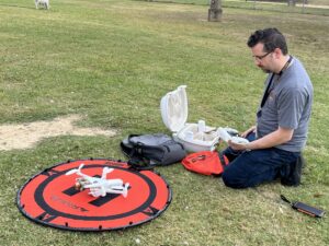 There’s a new drone and pilot available for TARCOG members in search and rescue situations, as a mapping and surveying assistant, to conduct agricultural monitoring, and even photography.
“If someone requires an eye in the sky, I’m always happy to help in any way I can, said James King, associate planner and geospatial technician.
The other part of James’ job, as a colorblind map maker, is being sensitive to making maps as user-friendly and accessible as possible.
“These are both tremendous skills on our team,” said Lee Terry, director of Economic Development and Planning.
Getting the job
James talked about the innovative ways drone technology can be used in economic development and planning during his job interview at TARCOG. That he has experience using one sealed the deal.
“I was trained on drone piloting in college and had done so recreationally from time to time, so the mention of it during my interview and eventual hiring certainly opened up possibilities for TARCOG,” he said. “I had flown drones that ranged in size from smaller than your palm to the size of a go-cart and enjoyed every moment.”
Getting the drone
James said a few months after he was hire, TARCOG acquired its current drone, the Parrot Anafi AI.
“It’s a wonderful machine. It’s basically a big grasshopper with propellers and has a whole host of features that allow it to be used as a multi-mission platform,” James said. “The day after we got it, I took and passed the FAA’s Part 107 license test, which is the industry standard for commercial drone pilots.”
FAA certified
He calls it a fairly simple test but added it requires due diligence and plenty of attention to detail. It tests your knowledge of FAA regulations, understanding airspace restrictions, and piloting basics.
“Since then, I’ve used the drone mainly for event photography and location scouting. But this only scratches the surface of what the drone can do,” James said.
Available for TARCOG members
Michelle Jordan, TARCOG’s executive director, said she’s excited to share the drone with TARCOG members in DeKalb, Jackson, Limestone, Madison and Marshall counties when it’s needed.
“This is an additional service we can provide for those unique situations in which a drone may be a helpful or even easier solution,” she said. “This is our way to let all of our communities know that TARCOG has this technology and a licensed pilot to help when needed.”
How to request the drone

To request the service, contact James at james.king@tarcog.us
“I’m always happy to get the drone in the air,” James said. “It’s one of the coolest things I do here at TARCOG and the part of my job I enjoy the most, I’m always excited when someone asks me to put the drone that I call the “Rising Hopper” in the air.
When he’s not flying the drone, James works on accessible maps as part of plans for various member projects.
Maps can be hard to read
Accessible maps are important to James. He explains in graduate school he went through his master’s program as part of a cohort of five geospatial scientists.
“Of the five of us, two had either dyslexia/dyscalculia which is issues with words/processing numeric-related things, and two of us were colorblind. I’m one of the colorblind ones.”
In addition, as a teacher while in college, he had students with the same type of challenges as he and his cohort.
“From my students and my cohort, we learned that maps needed to be more accessible to account for people with our challenges,” James said.
Simple changes, big difference
What he learned is that people with Dyslexia have trouble with crowded typefaces, or fonts with extra flare that adds clutter to the letters.
“Simply changing a font doesn’t cure the issues people with dyslexia have in processing words, but using fonts that are simple, clear tends to remove some strain,” he said. “I also do my best not to clutter the maps with too many numbers, or if I do, be sure that they are simple and direct in expressing their data, and also follow the same simplified typeface conventions that I use for Dyslexia.”
As a colorblind mapmaker, he overcame this challenge by using color palates that can easily be distinguished.
This can be as a simple as using colors that will easily contrast from one another, to adding textures like hatch marks or dots to various features, to even utilizing less color overall.
Trying to make it easier
“There is no simple answer to making maps for everyone,” James said. “Mapmaking is a visual art like any other, and making sure that they can be understood by our clients, my coworkers, and as many people as possible is of paramount importance to me.”